Drone services for construction projects are growing at a rate of 239%. Drone technology helps site managers execute projects with unmatched precision. With new advances in AI and cloud computing, the potential for drones on construction sites is truly limitless.
Drone services for construction can reduce cost and risk in the pre-construction, building, and completion phases of the project. Aerial site surveys and georeferenced maps are the most important current services. In the future, cloud computing, machine learning, and satellite imagery will create new services.
Drones provide many unique and valuable opportunities to decrease cost and risk in all stages of the construction process. In this blog we’ll review the current drone construction services then we’ll discuss some new capabilities you can expect to see on the horizon. If your considering purchasing a drone for your construction project then see our article “5 Best Mapping and Survey Drones“
Drones Services in The Pre-Construction Phase
Pre-construction includes pre-bid activities through land development and site preparation. Drone services in this stage center around land surveys, terrain analysis, and site imagery.
Land Survey
There are several pre-construction phase activities that pose a high risk to construction project timelines and budgets. These activities include site analysis, feasibility studies, and land surveys. Obtaining timely and accurate information is essential to minimizing construction-related risks.
Drone surveys reduce risk during the pre-construction phase by providing detailed imagery and data. The benefits of using drones for land surveys in the pre-construction phase include
Accuracy
Drone surveys can provide highly accurate topographic and site data, including elevation, contours, and land features. The accuracy is approx 6″ with normal GPS, and less than 1″ accuracy when using specialized GPS equipment. This reduces the risk of errors and omissions during the pre-construction phase.

Faster Data Collection
Drone surveys can cover large areas in a short period, collecting data that would have taken weeks or months to gather using traditional survey methods. This can help accelerate project timelines and reduce overall project costs.
Reduced Costs
Drones can access areas that are difficult and expensive to reach using traditional land survey methods. This can reduce site access costs and improve safety during the pre-construction phase.
Using drones for land surveys during the pre-construction phase, significantly reduce the risk of errors, speeds up project timelines, and reduces pre-construction costs.
Terrain Analysis
Engineers and architects can use digital terrain analysis products like digital surface models, orthomosaic maps, and contour maps to identify potential grading and drainage installation problems early on and take steps to mitigate them.
Aerial terrain analysis, using drone maps can provide low-cost earthwork (cut-fill) estimates. This gives companies an inexpensive way to optimize their project cost. Managers can avoid underbidding, which can lead to a net loss on the project, while also avoiding overbidding, which can lead to a losing bid.
Site Imagery
Potential investors have an interest in drone photos and videos that show site lines for views and provide basic land overviews. Drones provide low-cost aerial imaging to generate up-to-date detailed representations of the site.
Drones Services In The Build Phase
This stage of the construction project includes all building activities. Key needs during this phase are site safety and project schedule risk reduction. The main construction drone services are aerial site surveys and terrain analysis.
Site Survey
Professional drone operators generate periodic videos and photos of the site. Most of our customers opt for bi-weekly site surveys. We create secure webpages to host the bi-weekly data so that customers can easily see the work progression history.
These site surveys improve project management by providing near-real-time data on project timelines, progress, and compliance. Managers can monitor and document worksite status, track project advancements, and provide detailed data to stakeholders. Project managers can make informed decisions, identify work deficiencies, and detect potential issues in real-time.
There’s no more need to constantly walk the site to identify equipment or check construction progress. By removing the need for manual surveys, drone-based surveys reduce workers’ exposure to hazardous conditions and keep workers away from potentially hazardous areas on a construction site. Site surveys provide a convenient way to communicate progress to stakeholders, establish a record of asset locations, and verify completed work.
Terrain Analysis
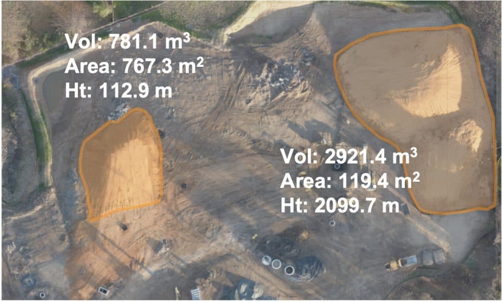
Drones generate georeferenced terrain imagery called orthomosaic maps. These maps can provide near real-time, highly accurate stockpile and earthwork measurements. Errors in stockpiles and earthwork can create big problems for your project.
Orthomiasic maps also allow detailed distance measurements so managers can compare actual build locations with the build plan to identify deviations and prevent reworks. Drone data can also be converted into 3D models to determine elevations and volumes.
Drone data can be overlayed CAD designs to spot errors and identify if the build deviates from architectural plans. Issues are identified far quicker than relying on traditional methods and can be acted upon immediately. This reduces the need for rework. Data for our customers is maintained on a secure website so that decision-makers and stakeholders can access this information remotely, without having to set foot on site.
Compared to land-based mapping, drone-based mapping can be up to 90% faster, and up to 75% cheaper. Also, aerial mapping does not interfere with ongoing activities. For details see our article “Aerial Mapping With Drones: A Business Perspective“.

Drones Services in The Completion Phase
This stage of the construction project includes final inspection activities through marketing and sales. Construction drone services for the completion phase include aerial inspection, videography and photography, and development of advertising materials.
Drone Inspection
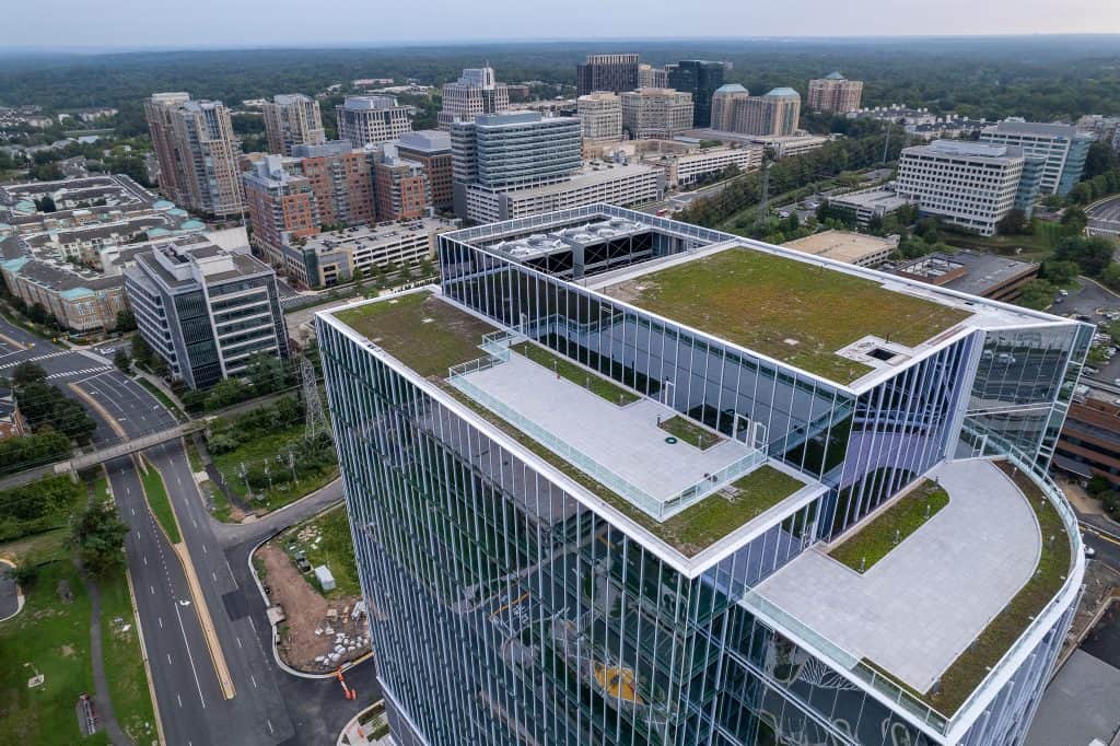
Drone inspection is particularly useful for high-rise buildings because it does not require scaffolding or ladders. This can significantly reduce costs.
Drones can quickly and easily access areas that would be difficult for people to reach, such as the tops of tall buildings under construction. In addition, drones can be equipped with special sensors to inspect heat emissions. This allows companies to assess heating efficiency.
Drone inspection performs all these tasks faster than traditional methods, creating a more streamlined inspection process for construction projects. For more information see our article “How To Start A Drone Inspection Business“
Videography and Photography
Once your project is complete, aerial photography and videography provide unique perspectives to showcase your work. This can be integrated with the progression videos to provide an impressive historical view of the project. However, drone photography and videography are not enough
You will need fully produced marketing products that can take the raw information and create professional cinematic products for your potential customers. Your best bet is to hire a company that offers drone services to collect data, and video production services to bring it all together. For more information see our articles “Drones for Marketing and Advertising“


Future of Construction Drone Services
Our view on the future drone services in the construction industry is that three technologies will be important: cloud computing, machine learning, and satellite imagery.
Cloud Computing
Cloud computing automates the aerial data process and provides near real-time results for project managers at a lower cost. This information is combined with other data to generate higher-value actionable results for the construction project.
Cloud computing and aerial drone imaging services can be integrated to automate processes, boost efficiency, and reduce costs. For example, cloud-based automation tools can help organizations streamline tasks such as data analysis, data management, documentation, and notification.
Additionally, cloud architecture offers the ability to operate at scale, meaning it can handle a large volume of data with ease. This increased capacity allows for quick and reliable notifications so that stakeholders are informed in real-time.
This technology also allows construction managers to remotely access construction data and documents from any location. Cloud computing can be used to store and share construction drawings and models. This can be extremely helpful when coordinating the construction project with multiple teams.

Machine Learning
The combination of machine learning and drone imagery for object identification and classification will be an important future capability. For example, machine learning algorithms can differentiate between objects with similar appearances, such as different types of piping or cabling to reduce the costs of asset management.
AI can enable real-time identification of potential hazards, such as structural damage or equipment malfunction, resulting in safer work environments.

Artificial intelligence (AI) applied to aerial drone images will actually predict building defects and compliance issues. By predicting these problems, construction companies will avoid costly delays and disruptions. Machine learning in construction is poised to become an essential tool for construction companies around the world.
The integration of cloud computing and machine learning will analyze massive amounts of data, from construction drawings to weather patterns and equipment usage. This combination will identify patterns of inefficiencies and deliver precise predictions in real-time.
This translates to accurate project timelines, cost estimations, and optimized resource allocation. By automating the prediction process, cloud computing reduces the need for human intervention, allowing construction professionals to focus on more critical issues such as risk management and decision-making.
The result is not only cost savings but also an enhanced ability to deliver projects on time and within budget. The future of the construction industry lies in embracing the power of cloud computing and machine learning to improve project outcomes in a rapidly evolving field.
Satellite Imagery
Lastly, construction drones and drone photography can be seen as complementary. Satellites provide wide-area lower-resolution images while drones high-resolution images over a smaller area.
One particular product we provide customers is a combination of satellite and drone imagery to build marketing and advertising materials. Satellite images present the project with respect to local amenities and access routes, while drone provides detailed site imagery.
The satellite industry is going through major transitions that will enable a new generation of drone software products combined with drone services, but drone companies will require technical expertise to capitalize on these advances. Any drone company should have an eye toward the future and the capability to leverage these technologies.
The Challenge For Drone Services
Drones are being used for site inspections, surveying and mapping, and project management. While these applications are useful, the combination of them does not make a single, instant, must-have application. We’ve found that our drone services are a “nice-to-have” if we can fit within the budget.
We are still searching for that “killer application” for drones in construction. Perhaps it will be found in some combination of future technologies. Despite this, it is clear that drones continue to be an important tool in the construction industry as they provide a new level of high-detail data, and can improve both safety and accuracy on job sites.
I hope that this blog post has helped to show you the many potential uses of drones for your construction site.
Lightwave Aerial is a professional drone service company based in Northern Virginia. Our pilots are all FAA Part-107 certified. We offer a full range of aerial photo/video production services, aerial mapping, and aerial inspection.
At Lightwave Aerial, we are dedicated to providing professional drone services that help our clients achieve their goals. Contact us today to find out more about how we can help you with your next construction project!

