We use the DJI Phantom 4 Pro (P4 Pro) aerial mapping on all of our jobs. The price-performance trade-off is great for our small business. But there have been a lot of new sexy drones released lately, so it’s a good time to see how the old P4 Pro compares.
The Phantom 4 Pro is a proven, reliable drone for aerial mapping. It has a mechanical shutter to minimize distortion and a 1″ 20MP camera that can provide 3″ ground resolution when flying at 175 feet AGL. All this can be purchased for under $2000.
We’ll compare the Phantom 4 Pro’s performance to potential competitors. As always, the article discusses technical performance from a business perspective.
Drone Mapping Introduction
Drone mapping is a process of capturing data from the air to create high-resolution 2D maps and 3D models. This is a form of remote sensing where data are collected through aerial photogrammetry or LiDAR (Light Detection And Ranging).
Aerial mapping with drones is faster and less expensive than traditional land-based mapping. Drones also offer a much safer way to map hazardous terrain compared to traditional mapping methods.
From a business perspective, photogrammetry gives a much better return on investment (ROI) vs LIDAR. In photogrammetry, the drone takes overlapping georeferenced photos.
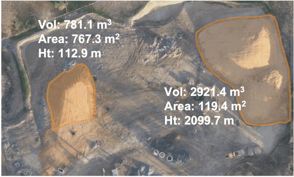
The photos are processed to create a geo-referenced terrain map called an orthomosiac map. These maps are used for a variety of applications such as detailed ground measurement, stockpile analysis, earthwork predictions, and digital terrain analysis.
Comparison of Drones For Mapping
| Phantom 4 Pro | Mavic 3 Enterprise | Air 2S | Mavic 3 Pro | Inspire 2 w/X4S | Phantom4 Pro RTK | |
| Resolution @ 175 AGL | 3.4″ | 4.4″ | 3.7″ | 4.4″ | 5.3″ | 1″ |
| Mechanical Shutter | Yes | Yes | No | No | Yes | Yes |
| Flight Time | 25 min | 47 min | 35 min | 40 min | 27 min | 25 min |
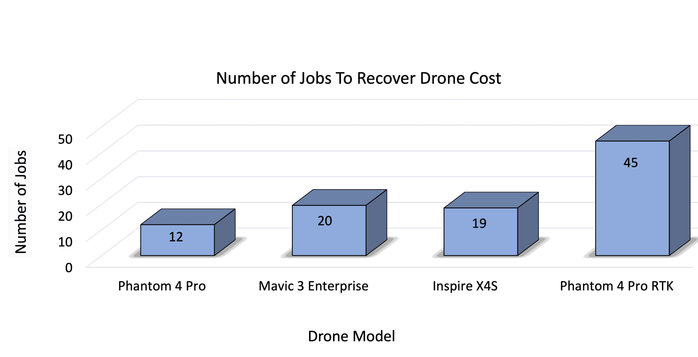
| # Jobs To Recover Cost | 12 | 20 | 8 | 15 | 29 | 45 |
Phantom 4 Pro Mechanical Shutter For Aerial Mapping
A unique feature of the Phantom 4 Pro is its global mechanical shutter. A mechanical shutter is particularly important for aerial mapping because it reduces rolling shutter distortion. This distortion occurs when the drone is moving or if the subject of the photograph is moving.
Most drones have electronic shutters. These shutters work the way we read, images are scanned row-by-row across the sensor. During the time it takes to complete the photo the drone has changed position and the image is distorted. This is a general problem in photography and it can significantly degrade the quality of aerial maps.
In contrast, a global shutter works like your eyelid where it snaps the entire picture at once.
Because of this, the Phantom 4 Pro images do not have the jello or wobble effects seen with electronic rolling shutters.
Phantom 4 Pro Sensor Size For Aerial Mapping
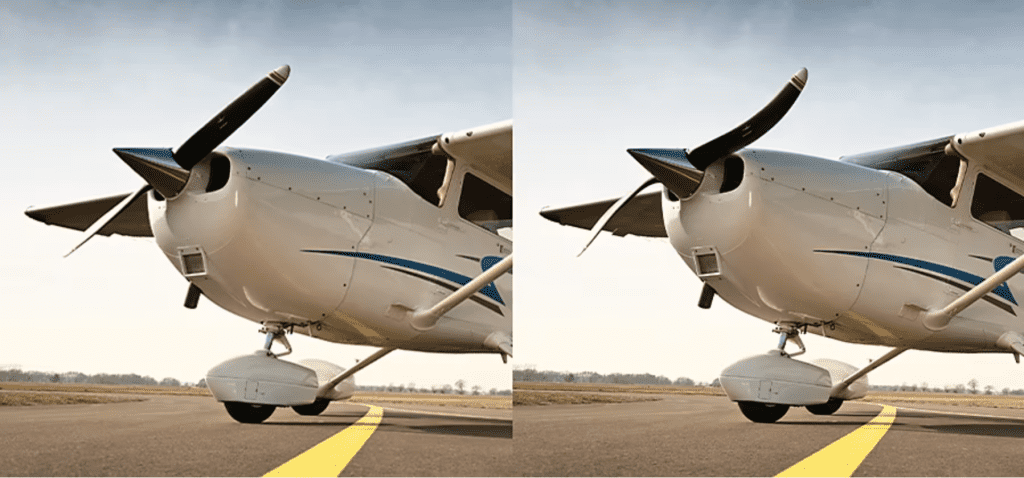
The Phantom 4 Pro has a 1” onboard camera sensor which is larger than the 1/2.3″ sensors in many other drones of comparable size.
A larger sensor size captures more detail and depth. It also provides better performance in low-light conditions. Newer drones like the Mavic 3 Pro have larger sensors, but they do not have mechanical shutters.
Phantom 4 Pro Camera Resolution For Aerial Mapping
The Phantom 4 Pro camera has a 20-megapixel resolution which relates directly to ground sampling distance (GSD). GSD is the size of one pixel within an aerial image relative to a given unit on the ground.
For example, a GSD of 4 cm means that each pixel on your aerial image will cover an area measuring 4 cm x 4cm on the ground. This means you can not distinguish between items that are closer than 4 cm.
Phantom 4 Pro Flight Time For Aerial Mapping
Longer flight time means more coordinated data collection without requiring a battery swap. Mapping times can vary depending on flight altitude, photo overlap, weather conditions, and your flight pattern. Our mapping jobs typically require from 20 to 60 minutes to complete.
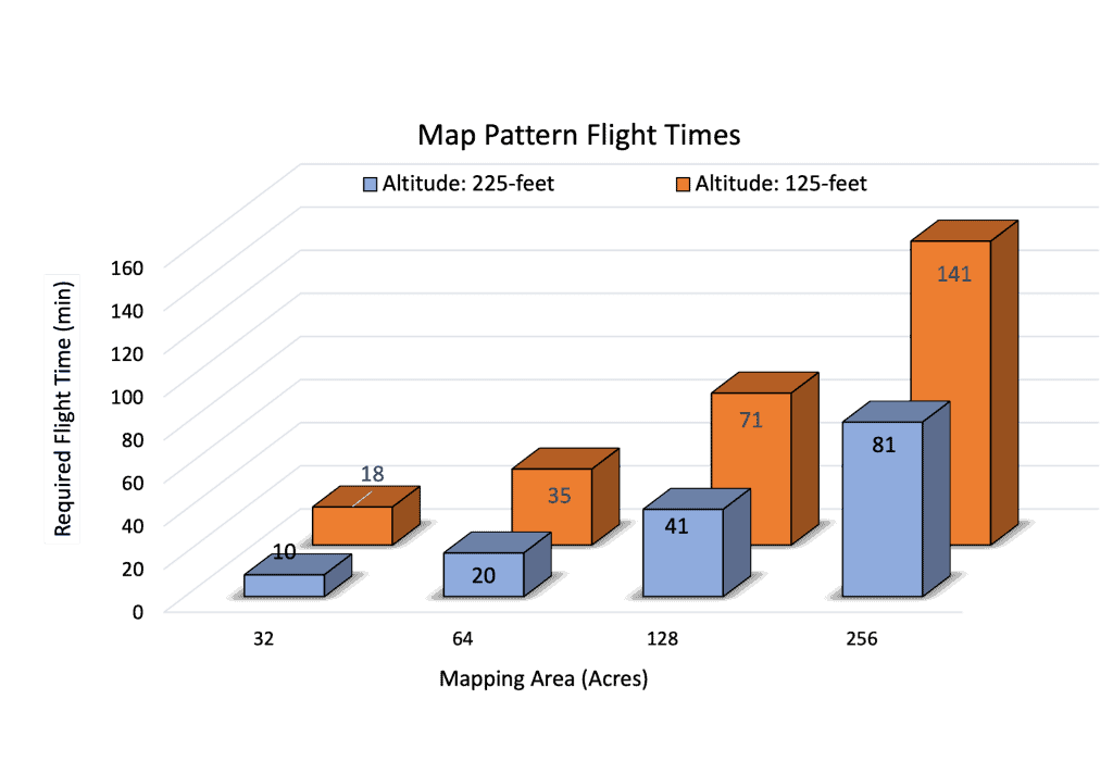
The Phantom 4 Pro flight time is 25 minutes, so we always have three batteries. I’ve calculated some flight times for different measurement areas.
The Phantom 4 Pro is a multi-rotor drone. If you need to map a very large area, at some point we recommend switching to a fixed-wing drone. All of our mapping business is in construction, so the Phantom 4 Pro flight works well for these jobs.
Phantom 4 Pro Cost For Aerial Mapping
When starting a commercial drone business the cost of the drone is an important factor. To be profitable you have to get enough jobs to pay for the cost of your drones. We’ve analyzed several mapping drones to show how many jobs you would need to recover the cost.
For more details on the impact of drone cost on your business see our article “Aerial Mapping With Drones: A Business Perspective“.
Phantom 4 Map Resolution For Aerial Mapping
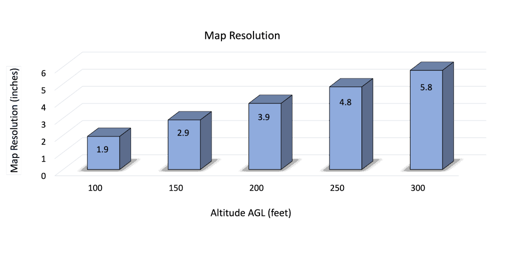
Map resolution determines the map detail. The orthomosaic map is a digital image made up of pixels. Each pixel represents a small area on the ground. The distance between pixels is called the ground sampling distance (GSD) and tells you the resolution of your map. A smaller GSD means better map resolution.
The GSD depends on your camera quality and the altitude of your flight. The best-case map resolution roughly equals twice the GSD. We’ve calculated the resolution for Phantom 4 Pro at different flight altitudes. We typically shoot for 3″ to 5″ resolution.
Aerial Mapping Software For The Phantom 4 Pro
Once you take your images you need software to combine your photos and create an orthomosaic map. There are a number of excellent software services that range in price and capability.
All of the software listed here provide high-quality 2D orthostatic maps and 3-D models from your drone images. The difference will be in price, ease of use, compatibility with other software, and extra bells and whistles.
Maps Made Easy (Our Recommendation)
Maps Made Easy (MME) is our choice because it’s super easy to use, provides excellent products, and has a fantastic price. It’s a completely cloud-based service.
There’s no upfront cost, all jobs below a certain size are free so you can practice as much as you want, and you only pay for what you use.
Each map costs us anywhere between $5 dollars to $15, and you have a unique option of reducing the price in exchange for a lower resolution. They have awesome technical support.
Their flight planning software is just OK, but for mapping missions, you don’t need too much capability.
Pix4D
Pix4D is the industry standard software for serious mapping professionals. This is the Cadillac of mapping software.
Pix4D also provides automated flight planning software (for free) but this is a relatively new product compared to Drone Deploy or maps made easy.
Most importantly, Pix4D is very expensive compared to other drone mapping solutions available in the market. My experience is that it’s difficult to learn, I would not recommend this unless you have some GIS experience and deep pockets (if you don’t know what GIS means, then you do not have enough experience).
Drone Deploy

Drone Deploy is another industry-standard software for drone mapping. It is known for ease of use, a cloud-based platform, and really well-integrated flight planning software. However, sometimes restrictions on the amount of data that can be stored may limit users when working with large datasets.
I tried Drone Deploy, it’s good and the flight planning software is great. But the cloud workflow was a little complicated and I felt like it should have been cheaper given that it’s cloud-based.
WebOMD
WebOMD it’s free, open-source mapping software. They have developed a full suite of services that are on par with other software products.
Be aware, it is more of a hands-on application so you may need a little bit of technical ability to use it, although it has gotten much simpler since it started. And the price is right.
There are several other excellent options to process your spatial data: Propeller, Raptor Maps, Agisoft. Howeve, we have not tested these applications.
Phantom 4 Pro Accessories For Aerial Mapping
Propellers

Your
Drone propellers tend to wear out over time. Also, minor crashes such as tipping over during take-off in a strong wind can damage the propellers.
Even small nicks or chips can impact the drone’s flight stability. Having an extra set is always a good idea.
Batteries

Typically in addition to the mapping flight, I’m taking a video in photos. Weather conditions are rough then the drone uses more power to fly the mission which will drain your batteries.
Neck Strap

I didn’t the
Wetsuit
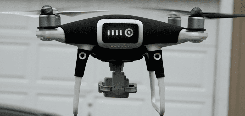
The wetsuit is designed to protect your fandom for P4 Pro went flying in the rain. I do not recommend flying in the rain even with a wetsuit. Our standard safety procedure is to postpone the flight if the weather is bad.
But the wetsuits work, and if you have to fly in the rain you absolutely need this accessory. For more details on flying in the rain see our article “Can You Fly Phantom 4 Pro In Rain“
Drone Hood

A
Landing Pad

The landing pad provides excellent protection for your drawing during takeoff and landings.
Other Great Mapping Drones
The Phantom 4 Pro is the industry standard drawing for mapping. It’s been around for a long time it has proven itself to be a workhorse for commercial operations.
However, there are some newer drones that can also provide excellent performance. We calculated the map resolution (= 4xGSD) and man-hours to recover the drone cost. We assumed each job takes 2 man-hours.
Mavic 3 Enterprise: $3700
| Resolution @ 175 feet AGL | Man-Hours To Recover Cost |
| 4.4 inches | 39 Hours |
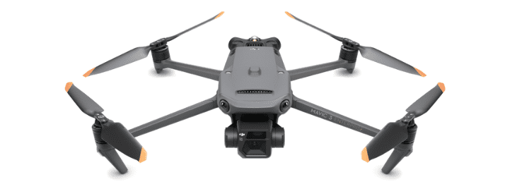
The DJI Mavic 3 Enterprise is the only drone of its size equipped with a global shutter. The drone is small and lightweight. Even though this drone was recently introduced, it is fully compatible with all 3rd party auto-flight software.
Inspire 2 with X4S: $4000 (est.)
| GSD @ 175 feet AGL | Man-Hours To Recover Cost |
| 9.2 inches | 40 Hours |

The
Phantom 4 Pro RTK: $8500
| GSD @ 175 feet AGL | Man-Hours To Recover Cost |
| < 1 inch | 89 Hours |
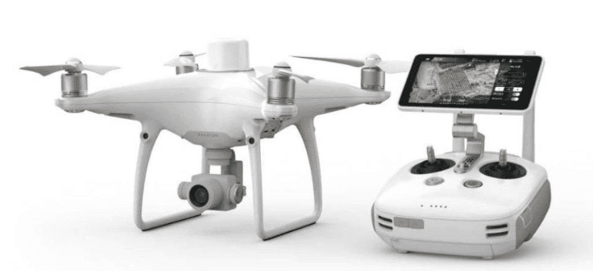
Phantom 4 Pro RTK version provides centimeter local and global accuracy by using something called RTK technology. For details on what this is see our article: “Aerial Drone Mapping: A Technical Perspective”
The RTK Version is much more expensive and probably won’t be necessary for most of your jobs. If you already have a P4 Pro then you can purchase an RTK upgrade kit.
Lightwave Aerial is a professional drone service company based in Northern Virginia. Our pilots are all FAA Part-107 certified. We offer a full range of aerial photo/video production services, aerial mapping, and aerial inspection.
At Lightwave Aerial, we are dedicated to providing professional drone services that help our clients achieve their goals. Contact us today to find out more about how we can help you with your next construction project!

