Have you ever seen a no-fly zone and wondered why your drone is not allowed to fly there? Well, you’re not alone. Many drone pilots are unsure of the rules and regulations regarding no-fly zones.
The FAA defines no-fly zones to prevent drone flights around sensitive or hazardous areas. The zones are divided into special use and controlled airspace. Drone vendors also use geofencing to enforce these no-fly zones. Geofences are divided into restricted, altitude, enhanced warning, and authorization zones.
In this blog post, we will review the details of no-fly zones.
What Is A No-Fly Zone
A no-fly drone zone is an area where drone operation is not allowed or restricted due to safety or security reasons. This could include areas around airports, military installations, national parks, forests, and other areas with sensitive infrastructure. In some cases, drone operators can apply for special authorization to fly in a no-fly zone.
No-fly drone zone restrictions apply to both recreational and professional operations. It’s important for drone operators to be aware of no-fly drone zones, as any drone operating in these areas may be subject to seizure or penalty.
No-Fly Zones: Special Use Airspace
Special-use airspace (SUA) typically covers areas that are restricted due to national security, military training, special activities, or hazardous conditions. These zones are usually marked with a “D” symbol on maps and drone pilots can find more detailed information about SUA on the Federal Aviation Administration (FAA) website. Violators of SUA face fines or other penalties
There are several types SUA’s. It’s important to understand each restriction in your responsibilities as a drone pilot. We’ve listed the most important SUAs below.
Prohibited Areas
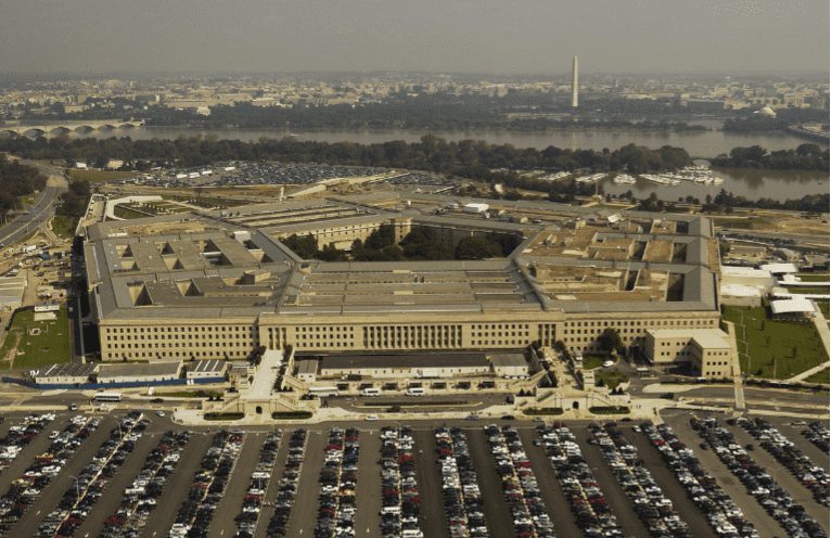
Prohibited areas are truly no-fly zones, often for national security. There is no way that a commercial or recreational pilot will be allowed access to this airspace. Examples will include the White House, the Pentagon, the CIA, and national parks (yes, that’s right). This airspace is only available to government agencies.
Restricted Areas
These are areas in which drone operation may be allowed but there are significant restrictions on the activities. For example, the airspace around Disney World is restricted as is the airspace around Washington DC. Drone operators are required to obtain special authorizations to fly. Obtaining permission to fly in these areas can be very difficult. Some restricted areas in DC require a law enforcement escort during the mission. See our article “How To Fly A Drone in Restricted Airspace“
Temporary Flight Restrictions (TFRs)
A Temporary Flight Restriction (TFR) is a type of Notice to Airmen (NOTAM). These temporary restrictions are due to weather hazards, special events, and national security to name a few.
Drone operators should check with their local aviation authority for any TFRs that may be in place. The text of the actual TFR contains the area, altitude, and timeframe of the restrictions. The FAA website maintains a list of active TFRs and a map of TFRs.

No Drone Zone
No-Drone Zone areas prohibit drone landing and takeoff. State, local, territorial, or tribal government agencies impose these restrictions. These areas protect the privacy of individuals and sensitive infrastructure.
Drones can not take off or land in these areas. If caught, drone operators will incur fines or other penalties. These No Drone Zones only restrict taking off or landing, you can still fly in the airspace above a No Drone Zone.
No-Fly Zones: Controlled Air Space
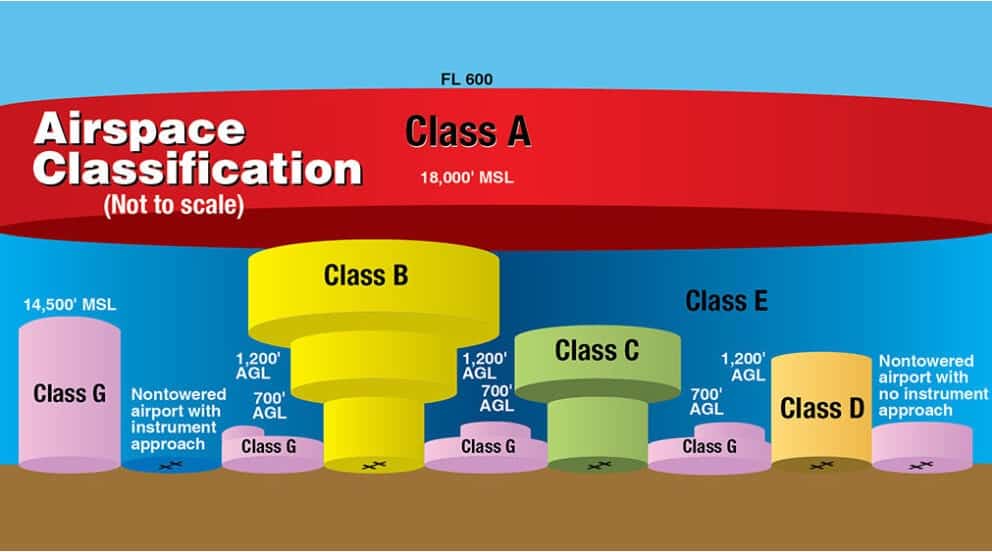
Controlled airspace includes Class A, B, C, D, and E airspace. Each classification of airspace has specific restrictions associated with it. The drone operator can obtain flight authorization through the Low Altitude Authorization and Notification Capability (LAANC). LAANC provides:
- Access to controlled airspace at or below 400 feet
- Awareness of flight altitude restrictions
- Air Traffic Control insight into all drones operation
Types of Controlled Airspace
Class A Airspace
Class A airspace is the most restricted of all controlled airspaces. It begins at 18,000 feet. Drone operations require special air traffic control permission to fly in this airspace. Even then, drone pilots need to have special permissions and certifications in order to fly at these altitudes.
Manned aircraft fly in Cass Aiairspace. It is unlikely you will fly at these altitudes. However, any drone operator that plans on flying in Class A airspace must contact the FAA and obtain authorization to fly. It is important that drone pilots understand the complexities of drone flight in this type of airspace.
Class B Airspace
Class B airspace is typically located around major airports and extends from the ground to 10000 feet MSL. Drone pilots must contact their local airport authority to obtain permission to fly in Class B airspace. The drone operator must show a valid reason for the mission. They must also demonstrate the proper knowledge and equipment necessary to safely operate their drone.
Class C Airspace
Class C airspace typically surrounds medium-size airports. It extends from the ground to 4000 feet MSL. Drone pilots must contact air traffic control (ATC) to obtain permission to fly in Class C airspace.
Class D Airspace
Class D airspace typically surrounds smaller airports. It extends from the ground up to 2000 feet MSL. Drone pilots must contact ATC for permission to fly in Class D airspace.
Class E Airspace
Class E is the most common type of airspace. It typically extends from 14,500 feet MSL down to 700 feet AGL, depending on location. While drone operators do not need express permission to fly within Class E airspace, they must still adhere to all relevant drone laws and regulations.
NOTE: You will also encounter Class G airspace. The airspace is uncontrolled, so don’t need to coordinate with ATC. The LAANC does not control these areas so you won’t be able to apply for authorization (because you don’t need it). As with Class E, just make sure you follow the relevant drone laws and regulations.
No Fly Zones: Geofenced Airspace
Geofencing is a drone technology that uses GPS or radio signals to create an invisible boundary around designated areas. The drone control software sets different levels of flight restrictions based on location. In some areas, the software will either not allow the drone to take off or it will force it to land.
The area around Washington DC is an example of a geofenced zone. Geofencing supports government airspace restrictions. However, drone vendors define and control the geofence. For details on geofences see our article “Geofencing For Drones: A Complete Guide“.
Types of Geofenced Zones
DJI defines several types of geofenced zones: restricted, altitude, authorization, and enhanced warning. These are the most important and you’ve probably encountered some of them.
Restricted Zone
Restricted zones prohibit drone flights for safety and security reasons. This includes airports, prisons, power plants, military installations, and other sensitive locations that have restricted drone access. The drone will be unable to start or take off in this zone. If you fly into one of the zones the drone may stop and hover or it automatically lands.
Altitude Zone
Altitude zones limit how high you can fly your drone. The drone will be able to take off, but it won’t be able to fly higher than the restricted altitude. These zones are in force even if you have been granted flight permission by air traffic control. This way pilot doesn’t accidentally fly too high and enter restricted airspace.
Authorization Zone
Authorization zones are areas where drone operations require additional authorization. Users can self-unlock this authorization in the form of a registration number or user identity. The drone will take off, but it won’t fly higher than 400 feet if the drone operator lacks the required authorization.
Enhanced Warning Zone
Enhanced warning zones are areas where drone operations require additional caution. The drone pilot will receive a warning when they enter the zone. Users must confirm that they wish to continue flying.
For more details on this subject see our article “Geofencing For Drones: The Complete Guide“
Why Do We Have No Fly Zones
No-fly and restricted-fly zones ensure that drone operations do not interfere with aviation activities, military training, or sensitive infrastructure. Additionally, no-fly zones support safe public events and protect national security
Who Defines No-Fly Zones
The Federal Aviation Administration (FAA) defines restricted airspace. The FAA can grant drone operators access to certain types of airspace, such as Class A, B, C, D, and E airspace. Additionally, the FAA can prohibit drone operations in other areas of controlled or uncontrolled airspace.
Local and state government agencies may impose drone restrictions for safety or security purposes. These agencies must obtain FAA approval before establishing any drone restrictions.
In addition to local and state governments, the Department of Homeland Security can restrict drone operations in certain areas due to national security concerns. The Department of Defense (DOD) also has some authority to establish drone no-fly zones.
How To Identify No-Fly Zones
There are several ways drone operators can identify no-fly zones. The first is to check the FAA’s list of temporary flight restrictions (TFRs). The TFR list describes prohibited drone operations areas.
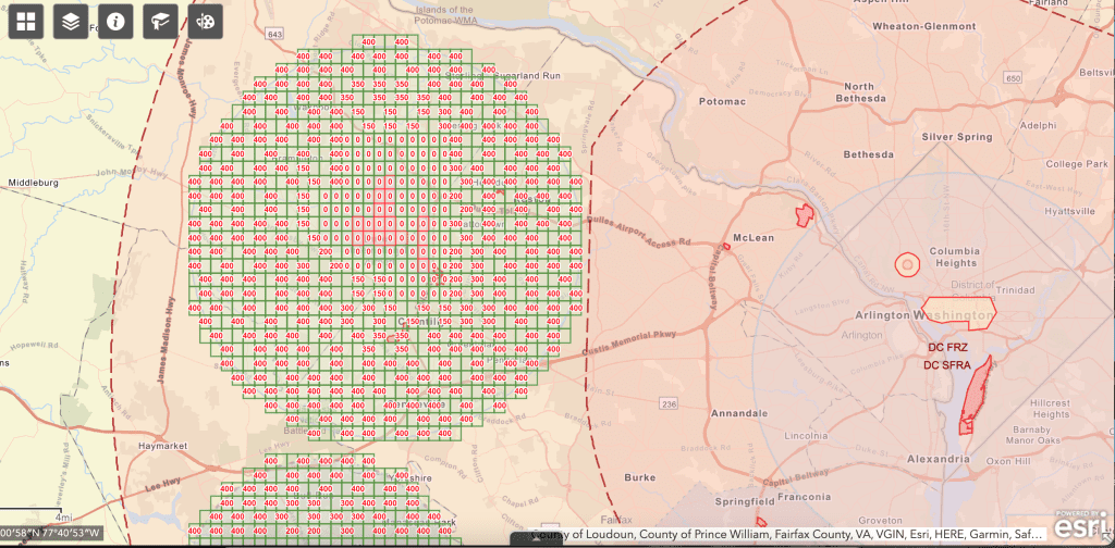
Drone operators can also identify no-fly zones using FAA facility maps or VFR charts. Facility maps provide drone operators with a detailed view of controlled and restricted airspace around airports, military bases, and other areas.
FAA VFR charts provide drone operators with a detailed view of airspace classifications and drone restrictions in different areas.
Drone operators can also check with their local aviation authority for any drone restrictions that may be in place. Additionally, drone operators can use drone mapping apps like B4UFLY or Airmap to get an aerial view of drone no-fly zones. These apps provide a layer showing drone restrictions and other airspace considerations for any area the drone operator plans to fly in.
Lastly, drone operators can use the DJI Geo Zone Map to identify geofenced zones around the world. This map shows drone restrictions in various countries and regions and provides drone operators with an overview of drone geofences.
Penalties for Violating
It is illegal to fly a drone in certain areas, and drone operators who violate these regulations can face severe penalties. The FAA can impose civil penalties ranging from $1,000 to over $20,000 for drone operations that violate airspace restrictions. Additionally, drone operators may face criminal charges for operating a drone in national security-prohibited airspace.

How to Access No-Fly Zones
In order to gain access to drone no-fly zones, drone operators must have a part 107 remote pilot certification. Then they must complete the process to obtain a flight waiver from the FAA. Drone operators will need to complete and submit a flight waiver package. This document must include detailed mission plans, mission risk and mitigation analysis, and additional documentation in order to receive clearance.
Waiver packages are submitted online to the TSA or the FAA Drone Zone, depending on the type and level of restriction. The FAA will review it and either approve or deny their request for authorization
In our experience, the FAA reviewers are extremely detail-oriented and any minor error or missing information will result in automatic rejection. You can fix the issue and reapply as needed. We typically end up making multiple submissions before getting approved. Response times tend to be within 48 hours which is pretty good. For details on the submission process see our article “How To Fly Your Drone in Restricted Airspace“.
Controlled Airspace
LAAANC will authorize most of your flights in controlled airspace. As long as you don’t get too close to an airport, it is a very simple process. There are a number of apps like Airmap or B4UFLy where you can obtain real-time approval will damn authorization
If you fly very close to an airport then you must obtain authorization from air traffic control through the FAA. Submitted your request online to the FAA drone zone website. The waiver package includes mission details and any additional safety measures.
The FAA will review the submission and either approve or deny the request. If approved, drone operators must then adhere to any additional restrictions imposed by the FAA before they can proceed with their drone mission.
Geofenced Airspace
In order to fly a drone in geofenced airspace, drone operators must first obtain authorization from DJI. To do this, drone operators must register for a DJI account and submit an application for authorization. You will verify that your flight is approved by the FAA. For more details on the application process see our article “Geofencing For Drones: The Complete Guide“
You must provide the drone model and serial number. Lastly, you will describe the proposed mission.
Conclusion
Being able to navigate the process to access no-fly airspace will differentiate your drone business. Drone operators must be aware of drone no-fly zones and adhere to any drone restrictions imposed by the FAA or other government agencies. Knowing the locations of drone no-fly zones is essential for safe and responsible drone operation.
Lightwave Aerial is a professional drone service company based in Northern Virginia. Our pilots are all FAA Part-107 certified. We offer a full range of aerial photo/video production services, aerial mapping, and aerial inspection.
At Lightwave Aerial, we are dedicated to providing professional drone services that help our clients achieve their goals. Contact us today to find out more about how we can help you with your next construction project!

